What are the shapes of the earth's surface on the continent. “Relief and landforms. Plains, lowlands, hills, plateaus
The earth's surface is formed under the influence of numerous external and internal processes that act on it with different speeds and forces. As a result, it takes on the most diverse and dissimilar forms - from the highest mountain ranges and small hills, to deep faults, depressions and gorges. What is the earth's surface? Which structural elements does it turn on? Let's find out.
Earth's surface
The earth was formed approximately 4.5 billion years ago, and since then its appearance has been constantly changing and transforming. Previously, it was a molten spherical body, but then its upper part solidified, forming a crust ranging from 5 to 150 kilometers thick. It is usually called the earth's surface.
Most of the crust is under water, the rest of it forms in the form of continents and islands. The World Ocean accounts for approximately 70% earth's surface. Below it, the crust consists of only two layers, it is much thinner and younger than on land. The bottom of the oceans has the shape of a bed, which gradually decreases from the shores of the continents.
Land covers approximately 30% of the planet's surface. Its crust consists of three main layers and reaches an average thickness of 40-45 kilometers. Large areas of land are called continents. They are unequally distributed on Earth - 67% of their total area is located in the Northern Hemisphere.
The earth's crust is not continuous and consists of several dozen tightly adjacent tectonic plates. They constantly move relative to each other, shifting every year by 20-100 mm. Weak movements are not felt at all Everyday life, but strong collisions can be accompanied by earthquakes and other natural disasters. Plate boundaries are unique “hot spots” on the planet. Volcanic eruptions often occur in these places, cracks and faults form.
Basic shapes of the earth's surface
The solid shell of our planet is constantly experiencing the action of internal and external forces. The movement of hot magma and tectonic plates, solar heat, wind, precipitation - all this affects it and creates various irregularities that are inherent in both the continental crust and the seabed.
There are several classifications of types of earth's surface, according to their characteristics. So, depending on whether they are convex or concave, they are divided into positive or negative. Based on the size and scale of the territory they cover, they are distinguished:
- Planetary forms - continents, ocean floors, and mid-ocean ridges.
- Megaforms - mountains, plains, depressions and plateaus.
- Macroforms are ridges and depressions within one mountainous country.
- Mesoforms are ravines, river valleys, dune chains and caves.
- Microforms - grottoes, karst sinkholes, potholes, wells and coastal ramparts.
- Nanoforms are small grooves and hummocks, folds and depressions on dunes.
Depending on the processes that influenced their origin, the forms of the earth's surface are divided into:
- tectonic;
- volcanic;
- glacial;
- aeolian;
- karst;
- water-erosion;
- gravitational;
- coastal (under the influence of sea waters);
- fluvial;
- anthropogenic, etc.
Mountains
Mountains are highly dissected elevated areas of the planet's surface, the height of which exceeds 500 meters. They are located in areas of high activity earth's crust and are formed as a result of the movement of tectonic plates or volcanic eruptions. and the nearby massifs are combined into mountain systems. They occupy 24% of the earth's surface, they are most represented in Asia, least in Africa.
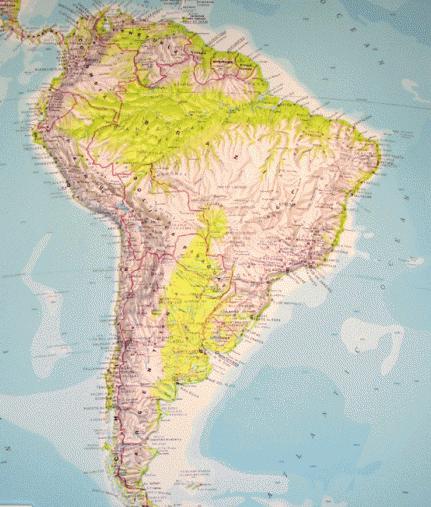
The Andes Cordillera is the longest mountain system in the world. It extends over 18 thousand kilometers and stretches along the western coasts of South and North America. The highest mountain in the world is the Himalayan Everest, or Chomolungma, with a height of 8850 meters. True, if we consider not absolute, but relative height, then the record holder will be the Hawaiian volcano Mauna Kea. It grows from the bottom of the ocean, from the foot to the top its height is 10,203 meters.
Plains
Plains are vast areas of terrain, the main difference of which is a slight slope, slight dissection of the relief and fluctuations in heights. They occupy about 65% of the earth's surface. They form lowlands at the foot of mountains, valley floors, flat or slightly undulating plateaus and plateaus. They can be formed as a result of the destruction of rocks, the spilling and cooling of lava, as well as due to the accumulation of sedimentary deposits. The largest plain on the planet - the Amazonian Lowland - covers an area of 5 million km 2 and is located in Brazil.

Mountains and plains are some of the most common landforms. Now let's look at the main genetic types of the earth's surface.
Fluvial relief
Water plays a huge geological role, changing and transforming the surrounding landscapes. Permanent and temporary watercourses destroy rocks in one place and carry it to another with currents. As a result, two types of relief are formed: denudation and accumulation. The first is associated with the destruction of rocks, its examples are beams, furrows, ravines, canyons, ledges and meanders. The second refers to the accumulation of geological material and manifests itself in the form of deltas, shoals, and plumes.

A classic example of fluvial relief is a river valley. The waters of the newly formed stream flow and make their way, forming channels, floodplains and terraces. The appearance of the river and its valley depends on the strength of the flow and the properties of the rocks underneath it. Thus, in soft clay soil, winding and wide watercourses often form. Among the hard rocks, rivers emerge with narrow valleys that turn into deep gorges and canyons. One of the most beautiful and largest in the world is the Grand Canyon in Colorado, reaching a depth of about 1600 meters.
Aeolian relief
Aeolian forms of the earth's surface are created by wind, by transporting small particles of dust, clay or light rocks. Thus, sand hills appear in deserts - dunes, the height of which reaches hundreds of meters. Dunes form along the banks of rivers; in other places, kuchugurs, loess and shifting sands appear.

Air currents can not only accumulate, but also destroy. By blowing out small particles, they wear down rocks, causing corrosion niches, rocks with holes and “stone pillars” to form. A striking example of this phenomenon is the Demerdzhi massif in Crimea.
Karst terrain
This landform occurs where rocks occur that are relatively easy to dissolve in water. Under the influence of surface or underground sources, various holes, tunnels and galleries appear in deposits of gypsum, salt, chalk, marble, dolomite, and limestone.

Karst forms are represented by caves, sinkholes, basins, gutters, karrs, shafts and gutters. They are widespread in the world, especially in Crimea and the Caucasus. This type of relief gets its name from the Slovenian Karst plateau, located in the Dinaric Highlands.
Technogenic relief
Humans also make a significant contribution to changing the Earth's surface. During the development of valuable deposits, a huge amount of minerals, soil and mixed rocks are removed from the bowels of the planet. In places of active development, voids and depressions appear in the form of quarries and mines. Tons of unused material are piled separately to form embankments and dumps.

Bingham Canyon in Utah, USA, is considered one of the largest quarries in the world. It is used to mine copper ore. The deepest wells of the quarry extend 1.2 kilometers down, and its maximum width reaches 4 kilometers. More than 400 tons of rock are mined there every year.
The concept of relief. Absolute and relative height
Relief. The earth's surface is extremely uneven. It features land and ocean. Within their boundaries there are grandiose mountain ranges and deep oceanic depressions, vast plains and underwater plateaus, lowlands, ravines, basins, dunes, etc. The relief is constantly changing, which is due to geological processes occurring under the influence of internal (movement of the earth's crust) and external (the work of flowing water, ice, winds, etc.) reasons.
The most important characteristics of the relief are absolute and relative height. Absolute altitude is the height of any point on the earth's surface above ocean level. It can be positive (the area is above ocean level) and negative (the area is below ocean level). Most of the land has a positive absolute altitude. Examples of negative absolute height are less common on land: Qattara Depression, Africa (-133m), Death Valley, North America(-85 m), Atlantic regions of the Netherlands, etc. In Russia, absolute heights are measured from the level Baltic Sea near Kronstadt.
Relative height is the elevation of one point on the earth's surface above another. It shows how much one point on the earth's surface is higher or lower than another. Absolute and relative heights characterize the ruggedness of the relief. There are positive and negative landforms. The largest negative landforms on Earth are ocean basins, while positive ones are continents. These are first order landforms. Landforms of the second order are mountains and plains (both on land and at the bottom of the oceans). The surface of the mountains and plains has a complex topography consisting of smaller forms.
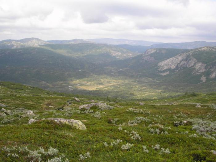
Plains, lowlands, hills, plateaus
Plains and mountains are the main forms of the earth's surface. They were formed as a result of geological processes that have shaped the face of the Earth throughout geological history. Plains are vast spaces with calm, flat or hilly terrain and relatively small fluctuations in relative heights (no more than 200 m).
The largest lowlands: Amazonian, La Plata, Mississippian, Indo-Gangetic, German-Polish. The Russian Plain is an alternation of lowlands (Dnieper, Black Sea, Caspian, etc.) and uplands (Valdai, Central Russian, Volyn-Podolsk, Volga, etc.). Plateaus are most widespread in Asia (Central Siberian, Arabian, Deccan, etc.), in Africa (East African, South African, etc.), in Australia (Western Australian).
Fig.1. Atherton Tablelands in Queensland (Australia)
The plains are also divided by origin. On the continents, the majority (64%) of the plains were formed on platforms; They are composed of layers of sedimentary cover. Such plains are called stratal or platform plains. The Caspian Lowland is the youngest plain, the East European Plain and the Central Siberian Plateau are ancient platform plains, their surface has been significantly modified by flowing waters and other external processes.
The plains that arose as a result of the removal of products of mountain destruction (denudation) from the destroyed base of the mountains (basement) are called denudation, or base, plains. The destruction of mountains and the transfer of rocks usually occurs under the influence of water, winds, ice and gravity. Gradually, the mountainous country smoothes out, levels out, turning into a hilly plain. Denudation plains are usually composed of hard rocks (Kazakh small hills).
Plains are divided by absolute height. Plains with an absolute height of no more than 200 m are called lowlands, or lowlands (West Siberian). Plains, the absolute height of which is from 200 to 500 m, are called elevated, or hills (East European, or Russian). Plains whose height is over 500 m above sea level are called high or plateaus (Central Siberian).
Plains formed in the process of accumulation (accumulation) of material, including loose sedimentary rocks, during which large relief depressions are filled with sediments, forming a leveled surface, are called accumulative plains (Great Chinese, Indo-Gangetic, Mesopotamian, Padanian, etc.) . Depending on their origin, they can be marine, lake, river, glacial, or volcanic. The relief of the plains is also varied. Thus, on the plains that have undergone continental glaciation, the relief of the areas of glacier feeding, its spreading and meltwater runoff - moraine and terminal-moraine shafts and ridges - is distinguished. The plains of the tundra and sandy deserts have a special relief. At the bottom of the ocean there are deep-sea (abyssal) plains; at the foot of the continents there are sloping plains; on the shelf - shelf plains.
Mountains, mountainous countries and highlands
Mountains are vast areas of land or ocean floor that are significantly elevated and highly dissected. Based on their appearance, mountains are divided into mountain ranges, chains, ridges and mountainous countries. Free-standing mountains are rare, representing either volcanoes or the remains of ancient destroyed mountains. The morphological elements of mountains are: base, or sole; slopes; peak or ridge (at ridges). The base of a mountain is the boundary between its slopes and the surrounding area, and it is quite clearly expressed. With a gradual transition from the plain to the mountains, a strip is distinguished, which is called the foothills. Slopes occupy most of the mountain surface and are extremely varied in appearance and steepness.
The summit is the highest point of a mountain (mountain ranges), the pointed top of a mountain is a peak. Mountain countries (or mountain systems) are large mountain structures that consist of mountain ranges - linearly elongated mountain uplifts intersecting slopes. The points of connection and intersection of mountain ranges form mountain nodes. These are usually the highest parts of mountainous countries. The depression between two mountain ranges is called a mountain valley. Highlands are areas of mountainous countries consisting of heavily destroyed ridges and high plains covered with destruction products.
Based on absolute height, there are three types of mountains.
Low mountains - absolute height from 500 to 800 m, slope steepness 5-10°, rounded, smoothed shapes of peaks and slopes. But there are also sharp, rocky forms. Rounded mountains - the Middle Urals, the Cis-Urals, the Kola Peninsula and Karelia, with sharp forms - the spurs of the Tien Shan, the ridges of Transcaucasia, the foothills of the Main Caucasus Range.
Medium-altitude mountains (medium mountains) with heights from 800 to 2000 m. The average steepness of the slopes is 10-25°, the relief forms are very diverse. Soft forms of relief are characteristic of the mountains of the Southern and Northern Urals, Crimean, Kopet-Dag, etc. Pointed, peaked peaks, sharp ridges, steep rocky peaks - the mountains of the Polar Urals, Novaya Zemlya, etc.

Fig.2. Konzhakovsky stone and Ostray Kosva (Northern Urals)
High mountains (highlands) - above 2000 m, slope steepness more than 25°. The high mountain zone is entirely rocky, the ridges are jagged, and characterized by sharp peaks and glaciers. Individual mountain peaks rise especially high. For example, the highest altitudes in the Himalayas are Chomolungma (Everest) - 8848 m, Chogori - 8611 m.
Mountains are divided into young and ancient. Young mountains are those that, from a geological point of view, arose relatively recently (Alps, Caucasus, Pamir, etc.). These mountains continue to grow, which is accompanied by earthquakes and, in some places, volcanism. In the ancient mountains, internal processes have long calmed down, while external forces continue to carry out their destructive work, gradually leveling them (Scandinavian mountains, the Urals, etc.). Based on their origin, mountains are divided into tectonic, erosional and volcanic. The most common type of mountains is tectonic (up to 90%), resulting from mountain-building movements of the earth's crust. Tectonic mountains are divided into folded, block and folded-block.
Folded - mountains that arise in areas of the earth's crust characterized by great plasticity and mobility. Here, over a long geological time, there is a powerful accumulation of sedimentary rocks, which leads to subsidence of these areas. The resulting counter lateral pressures lead to the crushing of sedimentary strata into folds and a general uplift of the entire region. Moreover, large blocks of the earth's crust rise in a peculiar way: one slope is steep, and the second is gentle. The uplift is accompanied by the formation of a foothill trough located nearby and resulting from the subsidence of the lithosphere. The asymmetrical structure of folded mountainous countries and foothill depressions can be traced in all mountainous countries. In the Greater Caucasus, Cordillera, Alps, Carpathians, Himalayas, Ural, Andes, and Pyrenees mountains, rock layers lie obliquely and curved. The main characteristic feature of folded mountains is their elongation in the form of chains of high mountain ranges over long distances, hundreds and thousands of kilometers.
Block mountains are uplifts of the earth's surface bounded by faults. They consist of layers of rocks folded into folds, have flat surfaces of peaks and steep rocky slopes of valleys. Block mountains arise as a result of faults, i.e. displacement of rocks along a vertical or steeply inclined crack, forming one or several fault steps with a displacement of 1-2 km. These are the Drakensberg Mountains in Africa, the Western and Eastern Ghats in India. During faults, peculiar processes occur - horsts and grabens are formed. Horsts - raised areas of the earth's crust, limited by faults: the Harz, Tarbagatai mountains, ridges Central Africa. Grabens are sections of the earth's crust that have been lowered along faults. Many of them host the largest lakes on Earth (Baikal, Great North American, and a number of lakes in Africa).

Fig.3. Drakensberg Mountains (Africa)
Folded block mountains appeared on the site of sections of the earth's crust that underwent mountain building in the distant past, but, collapsing, they turned into hilly plains. The soil in these areas has lost its plasticity and acquired rigidity and stability. Then these areas underwent repeated mountain building, which was accompanied by faults, faults, uplifts and lowerings of individual blocks (revived mountains). These are mountains with flat tops and steep cliffs - the Urals, Tien Shan, Altai, Sayans, Transbaikalia Ranges, Massif Central, Appalachians, East Australian Mountains, etc.
Volcanic mountains are composed of products of volcanic eruptions (bulk) and are isolated formations. In their height, volcanic mountains are not inferior to tectonic ones. Thus, the highest volcano on Earth, Aconcagua (South America), has a height of 6960 m. Erosion mountains are formed as a result of tectonic uplifts and their subsequent deep dissection by watercourses. The modern relief of eroded mountains was created mainly by the activity of flowing waters. Relief value in economic activity person is very large. The choice of settlement location, planning of cities, the most convenient places for the construction of hydraulic structures, nuclear power plants is accompanied by a detailed study of the terrain, especially in the regions permafrost, karst and landslide phenomena, earthquakes and volcanic eruptions.
Based on the structure of the layers, one can judge the nature of minerals in a given area and the resolution of water supply issues. Based on the types and forms of relief, areas favorable for Agriculture, placement of pastures, hayfields, irrigation and drainage of land. Relief plays an important role in shaping landscapes and climate. Due to their considerable height, plateaus and hills usually have a more dissected surface and rugged terrain compared to lowlands. Elevated plains with flat surfaces are called plateaus.
When studying geography and topography, we come across such a concept as terrain. What is this term and what is it used for? In this article we will understand the meaning of this word, find out what types there are and much more.
Concept of relief
So what does this term mean? Relief is a set of irregularities on the surface of our planet, which are made up of elementary forms. There is even a separate science that studies its origin, history of development, dynamics and internal structure. It's called geomorphology. The relief consists of individual forms, that is, natural bodies that represent its individual parts and have their own dimensions.
Variety of shapes
According to the morphological principle of classification, these can be both positive and negative. The first of them rise above the horizon, representing a rise in the surface. Examples include a hillock, a hill, a plateau, a mountain, etc. The latter, accordingly, form a depression relative to the horizon line. These can be valleys, beams, depressions, ravines, etc. As mentioned above, the shape of the relief is composed of individual elements: surfaces (edges), points, lines (edges), corners. According to the degree of complexity, complex and simple natural bodies are distinguished. TO simple forms include mounds, hollows, hollows, etc. They are separate morphological elements, the combination of which forms a shape. An example is a mound. It is divided into the following parts: bottom, slope, top. Complex shape consists of a number of simple ones. For example, a valley. It includes the riverbed, floodplain, slopes, etc.
Based on the degree of slope, subhorizontal surfaces (less than 20 degrees), inclined surfaces and slopes (more than 20 degrees) are distinguished. They can have different shapes - straight, convex, concave or stepped. According to the degree of extension, they are usually divided into closed and open.
Types of reliefs
The combination of elementary forms that have a similar origin and extend over a certain space determines the type of relief. In large areas of our planet, it is possible to unite several individual species on the basis of similar origin or differences. In such cases, it is customary to talk about groups of relief types. When a union is made on the basis of their formation, they speak of genetic species elementary forms. Most common types land relief is flat and mountainous. Based on height, the former are usually divided into depressions, hills, lowlands, plateaus and plateaus. Among the latter, medium and low are distinguished.

Flat terrain
Which is characterized by insignificant (up to 200 meters) relative elevations, as well as a relatively low slope slope (up to 5 degrees). The absolute heights here are small (only up to 500 meters). These areas (land, bottom of seas and oceans), depending on the absolute height, are low-lying (up to 200 meters), elevated (200-500 meters), mountainous or high (over 500 meters). The relief of the plains depends primarily on the degree of ruggedness and soil and vegetation cover. These can be loamy, clayey, peat, sandy loam soils. They can be cut by river beds, gullies and ravines.
Hilly terrain
This is a terrain that has an undulating nature, forming unevenness with absolute heights of up to 500 meters, relative elevations of up to 200 meters and a steepness of no more than 5 degrees. Hills are often made of hard rock, with the slopes and summits covered in a thick layer of loose rock. The lowlands between them are flat, wide or closed basins.
Hills
Mountainous terrain is an area that represents the surface of the planet, significantly elevated relative to the surrounding area. It is characterized by absolute heights of 500 meters. This territory is characterized by varied and complex terrain, as well as specific natural and weather conditions. The main forms are mountain ranges with characteristic steep slopes, which often turn into cliffs and rocks, as well as gorges and hollows located between the ridges. Mountainous areas of the earth's surface are significantly elevated above ocean level, while they have a common base that rises above the adjacent plains. They consist of many negative and positive landforms. According to the level of altitude, they are usually divided into low mountains (up to 800 meters), mid mountains (800-2000 meters) and high mountains (from 2000 meters).
Relief formation
The age of the elementary forms of the earth's surface can be relative and absolute. The first establishes the formation of relief relative to some other surface (earlier or later). The second is determined with the help of The relief is formed due to the constant interaction of exogenous and endogenous forces. Thus, endogenous processes are responsible for the formation of the main features of elementary forms, while exogenous processes, on the contrary, tend to level them out. In relief formation, the main sources are the energy of the Earth and the Sun, and we should not forget about the influence of space. The formation of the earth's surface occurs under the influence of gravity. The main source of endogenous processes can be called thermal energy planet, which is associated with radioactive decay occurring in its mantle. Thus, under the influence of these forces, the continental and oceanic crust was formed. Endogenous processes cause the formation of faults, folds, movement of the lithosphere, volcanism and earthquakes.
Geological observations
Geomorphologists study the shape of the surface of our planet. Their main task is to study geological structure and the terrain of specific countries, continents, planets. When compiling a characteristic of a particular area, the observer is obliged to determine what caused the shape of the surface in front of him and to understand its origin. Of course, it will be difficult for a young geographer to understand these issues on his own, so it is better to turn to books or a teacher for help. When compiling a description of the relief, a group of geomorphologists is required to cross the study area. If you need to make a map only along the route of movement, then you should expand the observation band as much as possible. And during the research process, periodically move away from the main path to the sides. This is especially important for poorly visible areas, where forests or hills interfere with visibility.
Mapping
Recording Information general(the terrain is hilly, mountainous, very rugged, etc.), it is also necessary to map and describe separately each element of the relief - a steep slope, ravine, ledge, river valley, etc. Determine the dimensions - depth, width, height, angles of inclination - often it is necessary, as they say, by eye. Due to the fact that the relief depends on the geological structure of the area, when conducting observations, it is necessary to describe the geological structure, as well as the composition of the rocks that make up the surfaces being studied, and not just their appearance. It is necessary to mark in detail karst sinkholes, landslides, caves, etc. In addition to the description, schematic sketches of the study area should also be made.
Using this principle, you can explore the area near which your home is located, or you can describe the topography of the continents. The methodology is the same, only the scale is different, and it will take much more time to study the continent in detail. For example, in order to describe it, you will need to create many research groups, and even then this will take more than one year. After all, the mentioned continent is characterized by an abundance of mountains stretching along the entire continent, Amazonian virgin forests, Argentine pampas, etc., which creates additional difficulties.
Notes to the young geomorphologist
When drawing up a relief map of the area, it is recommended to ask local residents where you can observe the places where layers of rock and groundwater emerge. This data should be entered on the area map and described and sketched in detail. On the plains, rock is most often exposed in places where rivers or ravines have cut through the surface and formed coastal cliffs. These layers can also be observed in quarries or where a highway or railway passes through a cut-out excavation. The young geologist will have to examine and describe each layer of rock, starting from the bottom. Using a tape measure, you can make the necessary measurements, which should also be recorded in the field book. The description must indicate the dimensions and characteristics of each layer, their serial number and exact location.
Subject: Shapes of the earth's surface.
Target:
- give an initial idea of the relief of the Earth, know the shape of the surface of the native land;
- identify different surface shapes from a map;
- develop interest in the surrounding world;
- fostering respect for nature.
Lesson type: combined.
Scientific and methodological content of the lesson: The main landforms of the Earth: mountains, plains, ravines, hills. Differences between mountains and plains in height.
Leading concepts: mountains, plains, ravines, hills.
Equipment: presentation on the topic of the lesson, models of mountains and mountain systems, map Krasnodar region, globe.
During the classes
- Organizing time.
- Lesson topic message
Today in the lesson we will talk about the surface shapes of our country, we will learn to find and distinguish them on the map.
(1 slide)
- Repetition of covered material
It will fall all over your palm.
There is not a clock, but a hand.
It will come in handy on the road -
You won't get lost anywhere with him.
- - What is this riddle about?
- - What is a compass? (2 slide)
- - Who uses it at work? (sailors, pilots, travelers, geologists, tourists)
- - Why do people use this device?
- - How does a compass work? Magnetic needle, housing, fuse.
- - By what signs can you navigate in nature? (3rd slide)
- by spring melting of snow on the slopes of ravines;
- by melting snow on the roofs of houses;
- there are more mosses and lichens on the north side;
- free-standing trees have longer and denser branches on the south side.
4. Work on the topic of the lesson.
How many of you have ever walked up a hill for a long time?
- How did you feel?
You probably thought that there is nothing better than a flat surface of the earth, which is very comfortable to walk on.
But in this case, we would not be able to live on such a flat planet, because... all the water would spread over the surface of the soil and you and I would end up at the bottom of the ocean more than two kilometers deep.
Therefore, it is better to leave it as it is: with mountains and plains, hills and ravines.
Look at the picture of sushi on globe.
Why is it full of different colors?( Land on the map is indicated by shades of green and brown.
- Think about what these colors mean.
- Compare images (4 slide)
- What surface shapes do you see?
- Try to explain what it is. - Why do you think? plain called the plain?
- Let's read about them in the textbook on page 76 (5 slide video about the formation of mountains, depressions, plains)
- What is a plain? (6 slide)
- What can you find on the plains? (hills and ravines)(7 slide)
Distinguish flat And hilly plains. They are marked on the map green and interspersed with light brown color.
Open the map of Russia in the textbook on page 90
- Find the plains on the map. Name them.
The plains seem flat only at first glance (8 – 14 slides) – view slides of the plains.
Look at the territory of our region on the map (individual cards)+ (15 slide)
- Are there any plains in our region? (Azovo - Kuban plain.)
Most of the territory of the region, located north of the Kuban River, is occupied by the Azov-Kuban Plain. (16 slide)
- How do you imagine a hill?
(17 slide)
A hill is a small hill with a rounded top and gentle or steep slopes, not exceeding 200 meters above the surrounding area.
The picture shows a view of the area: a river, a bridge across it, a hill. An oak tree grows on the hill. (18 slide) - hilly terrain. What do you think a ravine is?. On the plains there are not only elevations, but also depressions. Such reductions are
ravines(19 slide)
- How are they formed?
The formation of a ravine begins with a small pothole. Melt and rain waters wash it away, and the ravine gradually increases in size. Gullies can be shallow or they can be deep. A river or stream often flows along the bottom of a ravine. If there are a lot of grasses and bushes along the edges of the ravine, then it turns into a swamp.A ravine is a deep elongated ravine with steep slopes, washed away by rain and snow waters.
Ravines bring harm to people, because... They destroy the top fertile layer of soil, roads and cities suffer from ravines.
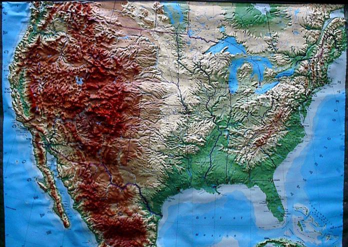
Find places on the map of Russia with a pronounced brown color.
- What do they mean?
Mountains are areas of the earth's surface that rise greatly above the surrounding area.
(21, 22, 23 slides) Mountains are high, medium high, low.
(24 slide) The hill and mountain rise above the surrounding area. They have the same parts:, foot, slope.
top What is the difference between hills and mountains?
(in height)
- Read the text on page 77. (under the picture)
- What is a sole? (read)
- What is a peak? (read)
- Open the map of Russia in the textbook on page 90 - Are there mountains in Russia? Name it.
(Ural Mountains)
(25, 26, 27 slide)
- Look at the territory of our region on the map(individual cards)+
(28 slide) (- Are there mountains?) Caucasus Mountains
(29, 30, 31, 32 slide)
The main mountain region of the Caucasus is the Greater Caucasus (33 slide) A grandiose mountain uplift consisting of numerous ridges. Approaching the Caucasus Range another 200 km away, you see the outlines of Elbrus, (34, 35, 36 slide)
The height of Elbrus is 5642 meters. This is the highest mountain in Europe.
The Caucasus State Reserve is located on the northern and southern slopes of the Main Caucasus Range. (37 – 45 slide)
Its main goals are nature conservation and restoration of the numbers of valuable species of animals and birds.
For your homework, you will draw the mountains of our region; whoever remembers will sign their names.
5. Practical work
Open your workbooks to page 32, task number 2 - label the parts of the hill. Page 33. No. 3 Draw a mountain and write its parts.
Examination:
6. (46 slide) Show them on a model (mountain model). Homework: V
printed notebook task No. 1, No. 4 p. 33, textbook p. 76-79 (explain)
7. Summary
(47 slide) Horizontally:
2. Large space of flat surface. (Plain)
4. The lowest part of the hill.
(Sole) Vertically:
1. An elevation more than 200 meters above the surrounding area. (Mountain)
3. The highest point of the hill (Vertex)
5. Winding, sharp decline in terrain
(Ravine)
- Does anyone know the name of the highest mountain in the world?
Guys, we will climb the highest peak on earth - the beautiful and inaccessible Mount Everest and get the opportunity to look at our land from the “roof of the world”! (video clip)
Literature: Used in the lesson: videotape fragment "
National parks
And this movement is determined by the movement of the mantle substance. As a result of such movement, mountains, ocean basins, and island arcs appear in the most mobile parts of the earth's crust. Stable areas of the earth's crust are characterized by flat surfaces. We call all this the relief of the Earth.
Continents and oceans- the main, largest landforms of the Earth. Their formation is due to tectonic, cosmic and planetary processes.
The mainland (continent) is the largest massif of the earth's crust, which has a three-layer structure: a sedimentary layer, a “granite” layer and a “basalt” layer. Average power continental crust 35-45 km. Most of the continent's surface protrudes above the level of the World Ocean. In the modern geological era, there are six continents: Eurasia, Africa, North America, South America, Australia, Antarctica.
The world ocean is a continuous body of water surrounding the continents. The world's oceans are divided by continents into four oceans: the Pacific, Atlantic, Indian and Arctic. Land accounts for only 29% of the Earth's area. Everything else is the World Ocean.
Mountains and plains, as well as continents and oceans, are the main landforms of the Earth. Mountains are formed as a result of tectonic processes in zones of active tectonic activity, and plains are formed in areas that are little susceptible to mountain-forming processes.
Plains- large areas with flat or hilly surfaces. They vary in height. An example of a lowland is the Amazon lowland - the largest on Earth. It happens that lowlands are located below sea level - these are depressions. The Caspian lowland is located 28 m below sea level. At an altitude of 200-500 m above sea level there are hills, for example Central Russian, and above 500 m there are plateaus. An example of such a plain is the Central Siberian Plateau.
Mountains- areas of the earth's surface elevated above sea level to a height of more than 500 m. Mountains are considered low if their height is from 500 to 1000 m; medium - from 1000 to 2000 m and high - over 2000 m. The highest mountain on Earth - Chomolungma (Everest) has a height of 8848 m. You can determine the height of the mountains by physical map using the height scale.
Mountains differ not only in height, but also in shape. A linearly elongated group of mountains is called a mountain range. The Caucasus Mountains have this shape.
There are also mountain belts (Andean belt), mountain systems (mountain system Southern Siberia) and mountainous countries. The Pamirs are an example of a mountainous country.
Mountains and plains are located both on continents and in oceans. An example of mountains in the ocean are mid-ocean ridges.
Relief of the Earth- the result of the struggle between internal and external forces. Inner forces Lands form large landforms: continents and oceans, mountains and plains. They not only form them, but also change and destroy them. External forces work constantly and slowly. They also destroy mountain ranges, fill up deep depressions, form hills, valleys, gullies, ravines, form river beds, that is, they form smaller landforms.
The destruction and change of rocks under the influence of fluctuations in air temperature, moisture and living organisms is called weathering.
Here are some examples of weathering. In the mountains these are landslides, landslides, mudflows, rockfalls, deep gorges cut by mountain rivers, moraine deposits of glaciers. For plains, typical examples of weathering are ravines and river valleys.